What is a Legal Description?
A Legal Description is a written description with the purpose of delineating a specific piece of real property, including Minerals. Getting it right is the most important part of any mineral or other land transaction. The property description must be “sufficient” in order to identify the correct parcel of land. That is, it must allow for the property in question to be identified on the ground with reasonable certainty.
In order to understand the legal description, you first must know what Survey System is used. Generally speaking, there are two Survey Systems that govern how tracts of land are described.
So, here they are:
The first is the Metes and Bounds system used in the 13 original colonies as well as parts of Hawaii, and Texas. The second is the Public Land Survey System, also known as the Rectangular Survey System.
Metes and Bounds
Metes and Bounds is method that is used by surveyors to describe a parcel of land. It uses precise angles, directions, and distances to describe the boundaries of the property in question. A Metes and Bounds legal description identifies a known landmark as the starting point, or Point of Beginning. From the Point of Beginning, it specifies a compass direction and a distance to the next property corner. From there, the next property line is described in the same manner until you return to the original Point of Beginning. This allows for an accurate description of irregular shaped lots.
So, what is the second system I need to know?
The second system is the Public Land Survey System (PLSS) (a.k.a. the Rectangular Survey System). It was established in 1785 and was originally proposed by Thomas Jefferson. The PLSS is the basis for land descriptions and conveyance for most of the U.S (with the exception of the states I mentioned earlier).
Public land survey system (PLSS)
Definition
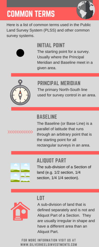
The Public Land Survey System or PLSS is also known as the Rectangular Survey System. It was established in 1785 and was originally proposed by Thomas Jefferson. The PLSS is the basis for land descriptions and conveyance for most of the U.S (with the exception of the 13 “original” colonies and a few other states).
This survey systems uses Sections, Townships, and Ranges to locate parcels of land.
You might be wondering:
What is a Section, Township, and Range?
Here’s the deal:
Townships
Townships are boundaries that are established at 6-mile intervals North-to-South andU East-to-West. Each 36 square mile (23,040 Acre) area represents a Township. To identify the Township, a “T” prefix is used along with a number that represents the number of Townships North or South of the Baseline.
Range
An area of land that is 6-miles wide and is established by a North-to-South boundary line. The Range is identified by a number that indicates the number of Townships East or West of the principle meridian along with an “R” prefix.
Section
Each Township is sub-divided into 36 sections which are generally 1 mile by 1 mile (640 Acres) in size. Sections are numbered from 1 to 36.
Sections can be further subdivided into quarter sections, quarter-quarter sections (called aliquot parts).
The legal land description of a section includes the Section Number, Township and Range with direction, State, and Principle meridian name. For example, Section 1, Township 4N, Range 61W, 6th Principal Meridian, Colorado.
To identify an aliquot part (individual parcel smaller than a section) the same convention is used along with the designated portion of the section. For example, SE 1/4 Section 23, T11N, R60W, 6th PM, Colorado identifies a parcel of land in the Southeast Quarter of Section 23, Township 11N, Range 60W, 6th Principal Meridian, Colorado.
What’s the bottom line?
This helpful diagram published by the Bureau of Land Management (BLM), shows in pictures what this all means.
Texas Land Survey System
As we mentioned earlier, Texas does not use the Public Land Survey System. Instead, it has one of the most complicated survey systems in the U.S. Parts of the system originate from early Spanish land grants that used a Metes and Bounds system. That sounds easy enough, right?
Wrong. It gets worse:
Rather than using one survey type, it uses three.
- League and Labor:
A “League” is made up of 4428 acres which is then sub-divided into 25 Tracts. These 177 Acre Tracts are called “Labors”. Labors can then be further sub-divided into lots.
2. Blocks
A Block is a subdivision of land that is made up of several surveyed tracts. These tracts are each assigned a unique number. Because they are irregular in shape, blocks and their related tracts use metes and bounds property descriptions. Blocks each have a name and or a number so they can be uniquely identified.
Did you know that Blocks don’t necessarily follow county boundaries and may cross counties?!
3. Township/Sections (wait, no Ranges?)
Fortunately the Township and Section system is only used in select areas of northwest Texas. It doesn’t use Ranges to specify distance from the principal meridian. Instead, a tract can be identified by the Survey Name, Block, Township and Section (e.g. Block 57 Township 1, Section 41, Survey T&P RR CO, Reeves County, TX).
Fortunately, there is hope!
Along as you understand the two primary survey systems, you will be able to translate the legal description of the parcel in question into a location on a map. From there, you can consult resources within the State and County where your mineral rights are located to help you narrow it down to the exact location on the surface of the Earth.
Thankfully, many states publish this information online and we can rely on technology to help us. This is especially useful in states such as Texas with complicated survey systems. The Texas Railroad Commission has a public GIS map viewer that is very helpful.
As you can see, getting the legal description right is critical in any oil and gas mineral rights transaction or sale.
This information is being shared for educational purposes only. This is not to be construed as legal advice! When in doubt, it is always a good idea to consult an attorney in your area experienced in mineral law.